Please do not reply to this Newsletter. You will likely get a response from a machine, not Nancy! For
feedback on the Newsletter or to correspond with Nancy, click here instead.
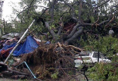
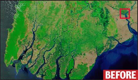
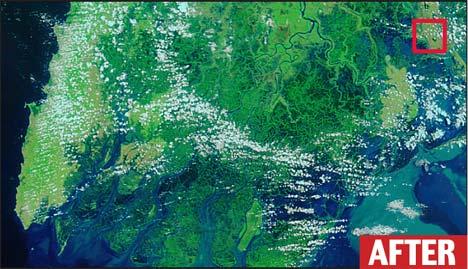
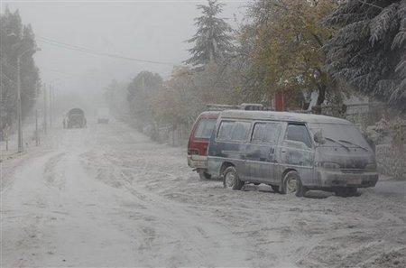
Burma Cyclone
Myanmar (formerly called Burma) was devastated May 7 as Cyclone Nargis slowly moved across its
delta region, drowning the region and leaving potentially 500,000 dead and an estimated one million of
people homeless. The extent of the flooding can be seen from satellite photos taken before and after the
cyclone hit.
- Burma Death Toll Worse Than Tsunami
May 9, 2008
http://www.thesun.co.uk/sol/homepage/news/article1143691.ece
- Last night's warning came as it emerged that 17 Britons, including ex-pats and
backpackers, were still missing. Sources said 200,000 people were already dead or dying.
But the figure could rise to half a million through disease and hunger if the nation's
hardline army rulers continue to block aid for the devastated lowlands of the Irrawaddy
Delta. That would dwarf the 230,000 deaths across South East Asia in the 2004
catastrophe.
- UN Officials: Myanmar Cyclone a 'Major, Major Disaster'
May 7, 2008
http://apnews.myway.com/article/20080507/D90GR35G2.html
- Corpses floated in salty flood waters and witnesses said survivors tried desperately to
reach dry ground on boats using blankets as sails. The U.N. said some 1 million people
were homeless in the Southeast Asian country, also known as Burma. Basically the entire
lower delta region is under water. State media in military-ruled Myanmar said more than
22,000 people died when Cyclone Nargis blasted the country's western coast on Saturday
and over 41,000 others were missing. Local aid workers started distributing water
purification tablets, mosquito nets, plastic sheeting and basic medical supplies. But heavily
flooded areas were accessible only by boat.
The Zetas have warned that devastation from tidal waves and hurricane force winds worldwide will
bring as much destruction during the coming pole shift as the magnitude 15 earthquakes and volcanic
eruptions that will be occurring. Coastlines are most vulnerable, as sloshing oceans and seas will force
the water inland first on one side and then the water will rush while retreating to the other side of a body
of water, presenting a force that none can resist. Simultaneously, there will be hurricane force winds and
earthquakes that will topple buildings. The Zetas advise that survival depends on moving to high ground
and finding shelter in low trenches out of the wind.
ZetaTalk Warning 1/15/1996: At the shift, the surface of the Earth will move, in just under an
hour, more than a quarter turn. Where massive earthquakes and tidal waves occur when this
motion stops, hurricane force winds, world wide, occur during this shift. Humans wishing to
prepare for these violent winds should anticipate a force equal to their familiar hurricanes, not
tornado force, although tornadoes will be spawned. Stay below the Earth's surface, lie low, and
tie down everything you wish to find when it's over.
ZetaTalk Warning 6/15/2001: This is a flood tide, with the lip of the water being its highest point,
rising like a silent tide endlessly on the rise, the wave rolling inland without a crashing back and
forth, just a steady progressive inundation. To those at the mercy of such a flood tide, their first
thought is to climb above the tide. Soon they are standing on the highest point they can reach,
and still the water, flowing inland steadily, rises. Afloat on a boat or flotsam, they will be
dragged inland with the flow until a reverse slosh begins, the water flowing back into its bed but
in the nature of water during a slosh, overshooting this other side so that both sides of the ocean
experience this flood tide, alternately, for some days until the momentum diminishes. When the
flood tide recedes, those afloat are in danger of being dragged far out to sea with the flow, as the
water will rush to its bed unevenly, more rapidly where it can recede the fastest.
Where Burma is getting assistance from around the world - food, clean water, medical supplies, and
shelter - after the pole shift such emergency assistance is unlikely to be available because all locales will
be similarly devastated.
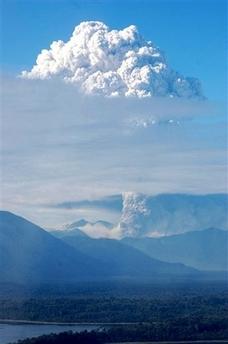
Chile Volcano
A long dormant caldera in Chile suddenly sprang to life, violently exploding and casting ash over a wide
area of Chile and adjoining Argentina.
- Chilean Volcano Town Nearly Deserted
May 3, 2008
http://news.yahoo.com/s/ap/20080503/ap_on_re_la_am_ca/chile_volcano_eruption
- The Chaiten volcano spewed light ash on a nearly deserted village Saturday, two days
after its first eruption in thousands of years. No more than 45 of Chaiten's 4,500 residents
remained in what looked like a ghost town, its streets, houses, cars and trees draped with a
thick layer of light-colored ash. Just six miles (10 kilometers) away, the volcano belched
fat smoke plumes that at times rose as high as 12 miles (20 kilometers) into the air. Winds
carried the ash to other towns in the region and across the Andes mountains to Argentina,
where two airlines suspended flights due to poor visibility.
Heavy volcanic ash was much in evidence, clogging the roadways and smothering rooftops.
- Chile Volcano Blasts Ash 20 Miles High, Forcing Evacuations
May 6, 2008
http://apnews.myway.com/article/20080507/D90GHEFO0.html
- Volcanic material from Chaiten's last eruption measured up to 5 feet in places. The gritty,
gray-white blizzard of ash covered houses and roads. Lava was rising within the crater but
has not yet spilled over.
The Chaiten volcano last erupted in 7,420 BC, almost 10,000 years ago!
- http://www.volcano.si.edu/world/volcano.cfm?vnum=1508-041
- Volcano Type: Caldera Volcano
Last Known Eruption: 7420 BC ± 75 years
The caldera is breached on the SW side by a river that drains to the bay of Chaitén, and
the high point on its southern rim reaches 1122 m. Two small lakes occupy the caldera
floor on the west and north sides of the lava dome.
The Zetas warned that all volcanoes active within the last 10,000 years should be assumed to be
candidates to erupt during the pole shift.
ZetaTalk Warning 11/16/2002: We have stated that all volcanoes active within the last 10,000
years can be considered candidates to blow or ooze during the shift. During every pole shift,
there are places on Earth where the earth is stretched, like the Atlantic, such that mountain
ranges such as the Appalachians have not experienced mountain building and scarcely any rock
outcropping are bare. Places like the Himalayas are subducting, so that rock layers are being
laid under one another, and protection from the lava occurs. Hawaii, likewise, is expected to do
better than one would think, because the compression of the Pacific will layer rock strata and
protect the oozing volcanoes from roiling lava. In New Zealand, where that edge of the plate will
tip up, it will be some protection from exploding volcanoes as the pressure will be relieved.
Likewise, where there is a stretch, as Iceland will experience, there will be continued oozing, but
explosions caused by lava under pressure unlikely to happen. Inland caulderas, like Yellowstone,
have their basis in pressure that has a long route to climb before heating the surface. During the
shift, the fact that they are and have been an outlet for pressure competes with what is occurring
in the rock strata. What comes first, for Yellowstone, will not be the rock strata thickening, as
during the start of the shift the Atlantic is stretched, the plates on the move, and the core roiling.
Thus, there will be explosions, though not violent, of lava, from volcanoes however active along
the Sierras and Andes. The later part of the hour sees rock strata pushed under the West Coast of
the Americas, shutting off access of lava from those volcanoes, which should speed the easing
but not prevent the explosion in the first place. In areas under stretch in Europe and the Middle
East, likewise, the roiling will cause oozing and where volcanoes are already open to the air, an
outlet established, such as in Italy, they will continue during the early part of the shift to explode
and ooze. One must, thus, analyze the past of local volcanoes or caulderas, to gauge their actions
during the shift.
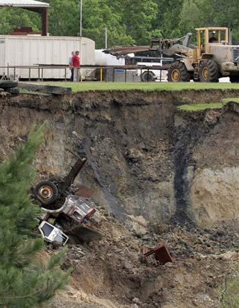
Texas Sinkhole
A massive, and growing, sinkhole suddenly made an appearance just east of Houston, Texas. Now up
to 3 football fields in length and an estimated 260 feet deep, the sinkhole is still growing. Terrified
residents in the nearby community of Daisetta fear for their homes.
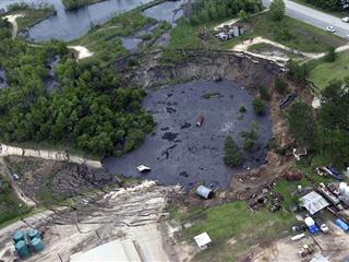
- Massive Sinkhole Widening in Southeast Texas Town
May 07, 2008
http://www.zimbio.com/Texas+Sinkhole/articles/2/The+Earth+is+Eating+Texas
- A massive sinkhole, which has swallowed up oil field equipment and some vehicles,
continued to grow Wednesday just outside the southeast Texas community of Daisetta. The
sinkhole was believed to be at least 600 feet long and 150 feet deep. Officials are trying to
determine what prompted the sinkhole near the Liberty County community. But its history
as a once booming oil town might be to blame. Officials say the ground might have caved
in because of the collapse of an old salt dome where oil brine and natural gas are stored
underground. Daisetta sits on a salt dome, one of the most common types of traps for oil.
-
- Regulators Hopeful Texas Sinkhole Won't Swallow Homes
May 8, 2008
http://www.foxnews.com/story/0,2933,354501,00.html
- Daisetta residents feared the appetite of the sinkhole, which began as a 20-foot hole in the
ground on Wednesday but had grown to 900 feet across and 260 feet deep. Officials are
still trying to figure out what prompted the sinkhole. Daisetta sits on a salt dome, a natural
formation created below the ground over millions of years where oil brine and natural gas
accumulate. Daisetta was once a booming oil town and today various working oil derricks
still dot the landscape. Norman said oil drilling from over the years might have weakened
the salt dome and caused it to collapse. But the sinkhole might also be a natural
occurrence caused by ground water leaking into the salt dome and dissolving parts of it.
Texas is prone to sinkholes because of the rock type. Oil and salt water brine are removed from caverns
during oil drilling, with the salt brine returned to the caverns so it does not pollute groundwater. The
higher concentration of salt brine in the caverns erodes the cavern rock to some degree, creating
fragility.
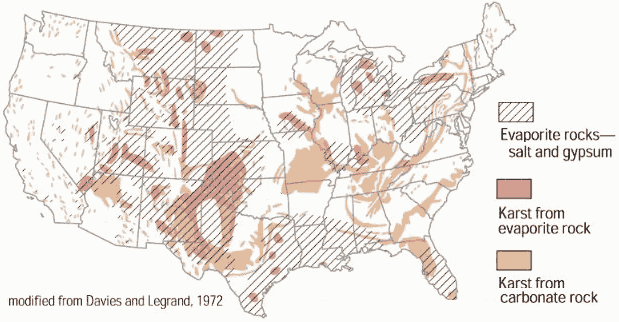
- http://ga.water.usgs.gov/edu/earthgwsinkholes.html
- Sinkholes are common where the rock below the land surface is limestone, carbonate rock,
salt beds, or rocks that can naturally be dissolved by ground water circulating through
them. The most damage from sinkholes tends to occur in Florida, Texas, Alabama,
Missouri, Kentucky, Tennessee, and Pennsylvania. The map below shows areas of the
United States where certain rock types that are susceptible to dissolution in water occur. In
these areas the formation of underground cavities can form and catastrophic sinkholes can
happen. These rock types are evaporites (salt, gypsum, and anhydrite) and carbonates
(limestone and dolomite). Evaporite rocks underlie about 35 to 40 percent of the United
States, though in many areas they are buried at great depths.
Certainly, as the pace of earthquakes picks up, such fragile caverns will increasingly collapse into
sinkholes, suddenly blocking roadways and changing the landscape so that a last minute dash to safety
could be faced with unexpected obstacles. The Zetas attribute the increasing incidence of sinkholes to
the stress on the rock in the N American continent. After the appearance of a dramatic sinkhole in
Guatemala, the Zetas also predicted an increase in these sinkholes as the N American continent
continues to be put under a diagonal pull. Once again, ZetaTalk prediction accuracy proved true!
- Massive Sinkhole Opens in Mexico City
July 9, 2007
http://www.msnbc.msn.com/id/19682106/
- Even in a city where historic buildings regularly lean, crack, collapse or sink below
sidewalk level due to excessive water extraction and unstable soil, the 45-foot-deep
sinkhole - which measures about 15 yards in diameter - came as a shock.
ZetaTalk Explanation 7/14/2007: We have mentioned that N America is being bowed and pulled
on a diagonal, and at some point large quakes along the New Madrid will occur. Mexico is being
pulled to the West, while New England is being pulled to the East. In addition, the West Coast is
being pulled into a bow near the Southern California area, which will create cracks in the
Arizona area. The recent sinkhole in Mexico is only more evidence of this.
- Giant Sinkhole in Guatemala
Feb 23, 2007
http://www.cbsnews.com/stories/2007/02/23/world/main2508879.shtml
- Two teenagers were killed when the giant 330-foot-deep sinkhole in a Guatemala City
neighborhood swallowed up several homes and at least one truck. Residents of the
neighborhood say others are still missing but it has not yet been confirmed. The giant
sinkhole is emitting foul odors, loud noises from below are being heard and tremors are
shaking the surrounding ground. When a rush of water was heard from its depths the
authorities feared it could widen or others could open up. Apparently residents had been
hearing noises and feeling tremors for about a month waking them from their sleep until
this morning when the giant sinkhole claimed everything on its surface.
ZetaTalk Explanation 2/24/2007: We have explained in great detail the pre-shift quakes that will
occur, the manner in which the plates of the crust will move. S America is nailed at the tip, as N
America is at its top, unable to roll due to the straight line from Japan to Iceland that locks it.
Thus, as the Atlantic widens at the Equator, S America rolls to the West, crushing Central
American and the Caribbean while it does so. N America pulls diagonally, a situation that will
soon erupt creating quakes and sinking ground and disaster in almost every State of the Union.
For Central America, such a horror as a 330 foot deep sinkhole, hardly caused by a broken
sewer line, is just the start. The question for those trying to placate their nervous heart over this
matter should ask, 'what caused the sewer line to break, in the first place?'
Video Clip on New Madrid
 The Zeta Report 19 - New Madrid Fault - When will it snap? The Zeta Report 19 - New Madrid Fault - When will it snap?
Click on the image or click Here to watch.
You received this Newsletter because you subscribed to the ZetaTalk Newsletter service. If undesired, you can quickly
Unsubscribe.
|