Viva
the Mexican Heart
On March 20, 2012 a 7.9 quake occurred in the Mexican state of
Chiapas, though it was later downgraded by the USGS to a mere
7.4 quake. What is most interesting is that just two minutes
prior to the quake a government exercise in preparation for just
such a quake, a 7.9 quake, had begun! Because of this, office
buildings and schools had been emptied, and many lives were
saved.
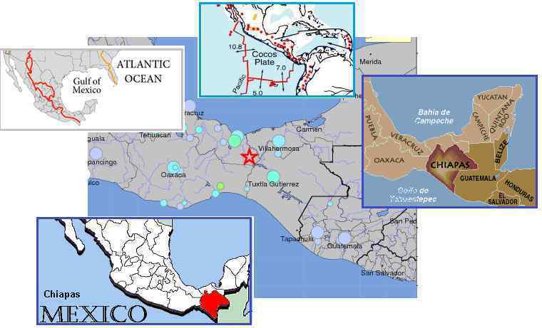
- Earthquake Drill Coincidence on CNN
March 20, 2012
http://mexico.cnn.com/nacional/2012/03/20/chiapas-preparaba-macrosimulacro-y-vivio-un-sismo-real
- The
state of Chiapas was preparing for a macrosimulacro of 7.9
degrees on the Richter scale at 12:00 hours and two
minutes later there was a real earthquake with an
epicenter 7.8 degrees in the southern state Guerrero. The
macrosimulacro allowed the evacuation of schools and
government buildings a success. But the trial scheduled at
12:00 was fulfilled in an event at 12:02 hours.
- Strong Quake Hits Mexico
April 2, 2012
http://www.rawstory.com/rs/2012/04/02/strong-quake-hits-mexico-no-casualties-reported/
- The
epicenter had been hit by a 7.4-magnitude quake on March
20, which killed two people and injured 13 others. That
earthquake — with its epicenter south of the Pacific
resort of Acapulco — was the most powerful to hit the
country since a deadly tremor in 1985, which destroyed
entire neighborhoods of Mexico City and killed thousands.
Per the Zetas, the timing was no accident, and is an example of
what human being can do when they are concerned about others.
This is a quake that humming metal
boxes such as were discovered along the Oregon coast
delayed. The time for an adjustment at the tip of Mexico could
no longer be delayed, but due to the Call being given by parties
in Mexico, the release was timed to occur just after the
exercise. Viva the Mexican heart!
ZetaTalk Explanation
4/7/2012: The
Chiapas region of Mexico is along the border with the Cocos
Plate, and thus during the S American roll, when the Caribbean
Plate and those parts of the N American Plate attached to the
Caribbean Plate are pushed westward, Chiapas is pushed over
the Cocos Plate. As can be seen from Continental Divide maps,
the Cocos Plate is pushed under this region to the point where
the March 20, 2012 quake struck. This is what the Continental
Divide represents, the point where subduction under the plate
has pushed in the past.
When the humming metal boxes
were discovered on an Oregon coast we explained that the
Council of Worlds had allowed the 7 of 10 plate movements to
be restrained and delayed until the cover-up had been
attacked. We mentioned that the discovered boxes were
hardly the extent of this effort, which is ongoing worldwide
and extensive. Certainly, damage from the bowing of the N
American continent as the Pacific compresses and the top part
of S America rolls westward has been restrained, but there is
a point where restraint is no longer possible. Chiapas had
reached that point.
There are many strongly
Service-to-Other individuals in Mexico, some in authority, and
when giving the Call to assist their fellow countrymen they
were told of this pending quake, and a plan was hatched. They
would call an exercise and we would release the restraint, and
voile perhaps thousands of lives were spared. A historically
equivalent quake had indeed killed thousands. This is an
example of the power of Service-to-Other teamwork, what the
future can bring when those with great love in their hearts
refuse to be passive but take action. Viva the Mexican heart!
N America Diagonal
Yin-Yang
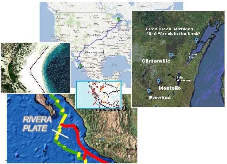
The N American continent is being pulled into a bow as Mexico
is pulled to the west while the continent remains unmovable at
its top. Is there a relationship between the booms in Wisconsin
towns and the adjustments along the Mexican Pacific coast? Per
the Zetas, there is indeed. Wisconsin has pulled apart in the
past, and a growing
crevasse in Menominee, Michigan on the peninsula above
Green Bay, Wisconsin has continued to spread since its discovery
in 2010, as noted in Issue 207 of
this newsletter. As noted in this Pole
Shift ning blog, there seems to be a relationship in time
between adjustments in Wisconsin and Mexico, which are going
back and forth. Last week, in Issue 287
of this newsletter, we covered the booms in Clintonville and
Montello, Wisconsin. Now the booms have moved along a diagonal
line down to Baraboo! Meanwhile the Mexican quake at Chiapas has
caused an adjustment up the coast at the Baja peninsula. Per the
Zetas, no coincidence!
- Bara-Booms Remain a Mystery
April 4, 2012
http://www.wiscnews.com/baraboonewsrepublic/news/
- A
resident on Sauk Avenue called 911 to report a loud boom
Sunday [April 1] around 1 am. About 45 minutes later,
residents throughout the city called authorities to report
a second flash and boom. A Baraboo police officer
witnessed the first incident while parked on the 800 block
of Eighth Street.
- There Saturday-Gone Sunday-Los
Frailes Facelift
March 28, 2012
http://www.bajafisherman.com/forum/showthread.php?972-There-Saturday-gone-Sunday
- Sunday
morning the beach in Los Frailes disappeared - lost
forever were 200 meters of beachfront by 100 meters deep.
The red line is where the beach was the day before. The
angler that emailed the photo in said the beach
disappeared very quickly and is now a steep bank that
appears to still be slowly eroding.
ZetaTalk Explanation
4/7/2012: We
have described the N American bow as one where the tip of
Mexico moves west while the top of the continent at Alaska and
Canada remains in place. This pulls the entire continent into
a bow shape which can only be relieved by the New Madrid
adjustment, tearing the continent at a diagonal so that that
the southwest of the US and Mexico move west and down while
lands east of the Mississippi are torn away. In the meantime,
the stress of the bow is pulling the St. Lawrence Seaway apart
where resistance is slight. As we have mentioned, Wisconsin is
pulling apart, and the rock strata there allows separation
readily.
It is no surprise that a
crevasse on the Michigan peninsula has been joined by booming
in towns to the south as rock snaps in a diagonal line toward
Mexico. Mexico very recently had an adjustment at its tip,
driving the tip over the Cocos Plate. The land having moved
westward, adjustments moved up along the coast. The Baja
coastline affected literally touches the San Andreas fault
line. It is no surprise likewise for these bow adjustments to
occur almost simultaneously. On March 18 Clintonville began
booming. On March 20 Chiapas at the tip of Mexico adjusted. On
March 20 the Clintonville booms moved down diagonally to
Montello. On March 28 the Baja beach disappeared. And on April
1 the Clintonville booms moved along diagonally to Baraboo.
Most definitely related!
Buoy 46419 Waves
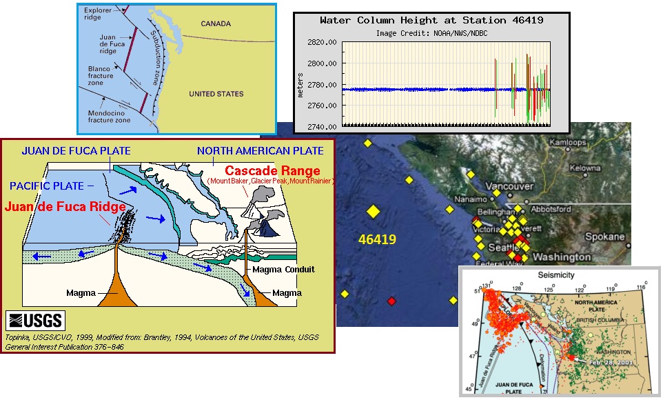
Buoy 46419 has been showing heaping and falling water at times
to an astonishing degree for the past couple months, as this Pole
Shift ning blog shows. The graph below represents activity
between December 1, 2011 and March 29, 2012 – a four month
spread. Note that by late February the buoy was recording
heaping and dropping water with a span of 65 meters, i.e. 195
feet! Note the location on the Juan de Fuca Plate border, where
the Juan de Fuca Ridge is developing from rising magna. The
plates are pulling apart there, while the eastern edge of the
Juan de Fuca Plate is pushing under N America. This allows the
western edge to flap, essentially, under the water, rising and
falling with magma pressure as the northern Pacific compresses.
The heaping and falling water is very real! This is not a broken
buoy. As proof stands the battered cargo ship Dry Beam, which
sustained damage from high waves on February 7, 2012.
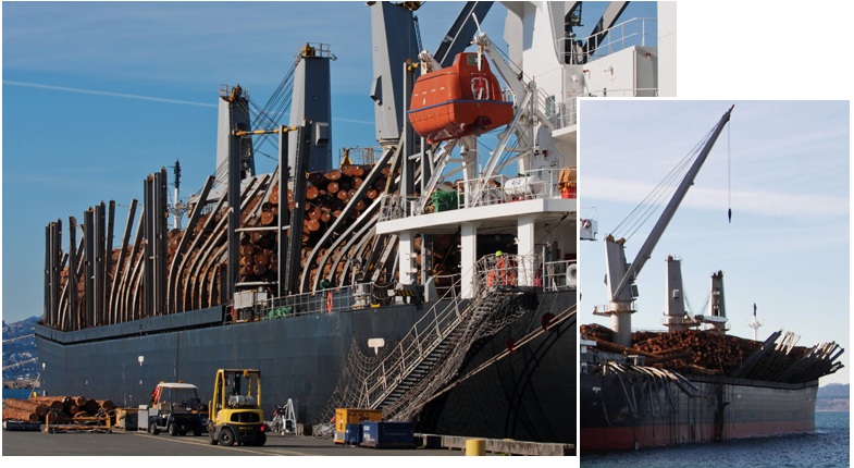
- Massive Rogue Wave Hammers Cargo Ship
off the BC Coast
February 7, 2012
http://news.nationalpost.com/2012/02/07/rouge-wave-dry-beam/
- The
186-metre cargo ship Dry Beam is moored at Ogden Point in
Victoria, its massive vertical support beams bent like
matchsticks and its load of logs shoved askew by a rogue
wave on the North Pacific. The vessel was en route to
Japan from Washington state Thursday night about 480
kilometres off northern Vancouver Island, when it ran into
trouble, lost some logs and issued a mayday call. A rogue
wave had pummelled the ship’s left, or port, side and
caused many of the raw logs on the deck to shift toward
the starboard side.
Fiji Flooding
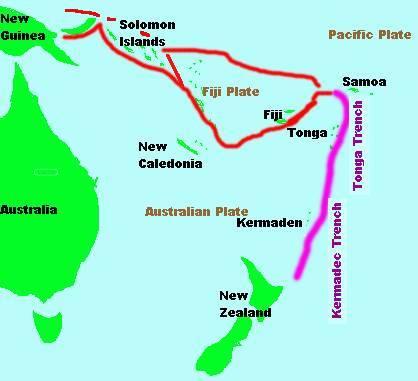
The Zetas have predicted that in the squeeze of plate movements
the little platelet that the islands of Fiji reside on will be a
loser, pushed down.
ZetaTalk Prediction
1/15/2011: The
islands at the plate borders in this region do not do well
during the plate adjustments to come. The primary devastation
will come during the hour of the pole shift, but the
devastation has started during the 7 of 10 adjustments. Samoa
rides on the Pacific Plate, which is pushing under the eastern
edge of the Indo-Australian Plate, and as this process
continues and accelerates, approaching the pole shift, will
virtually disappear. The Solomon Islands do not fare much
better, for the same reasons. Tonga and New Caledonia ride
high. The little Fiji Plate, as the recent sinking indicates,
will be a loser, pushed down into the notch as the Pacific
Plate presses ever westward.
This process seems to have begun, as this Pole
Shift ning blog reports. Fiji’s flooding appears to be
more than just rain. The land is sinking, and the drainage
affected.

- Worst Floods 'in Living Memory' in
Fiji
March 31, 2012
http://www.3news.co.nz/Worst-floods-in-living-memory-in-Fiji
- Three
people have died and dozens are missing after Fiji has
been hit by massive flooding for the second time in three
months. There is widespread damage on the island of Viti
Levu, particularly in the towns of Nadi, Ba and Lautoka
and the flooding left dozens stranded on buildings and
forced the cancellation of flights in and out of Fiji.
- Tavua Town Now Flooded
April 1, 2012
http://www.fijivillage.com/?mod=story
- Officer
in charge Joseph Law confirmed that this the first time
for flood waters to reach Tavua Town and its knee length.
Red Filter
Revolution
It has gone viral, and worldwide. No stopping it now! Look what
has emerged in just a week or so on the Pole
Shift ning blog dedicated to images of Planet X.

These photos were taken on March 31, 2012 at 1:55 pm in Lincoln,
NE. The reason for all the photos is to show that no matter
where the camera is pointed, the object (possible moon swirl)
always stays at the 12 o’clock position. Nothing major like
Venus or Jupiter at 12 o’clock.
Torino, Italy on March 29, 2012 at 11:00 am.
[and
from another]
Springfield,
Oregon on March 28, 2012 at 11:20 am
[and
from another]
Germany,
March23, 2012 at 18:04 using an iPhone 4 with double floppy
filters.
[and
from another]
Australia
on March 21, 2012 at 8:49 pm
[and
from another]
Cairo,
Egypt on March 18, 2012 at 8:30 am taken from my Nokia 9500
phone with a floppy disc filter on the camera.
Slowing Rotation
Early in the ZetaTalk saga the Zetas predicted a slowing
rotation as the time of the pole shift approached.
ZetaTalk Prediction
1/16/1996: This
increasing slowdown will get diminishing press coverage, as
clocks are quietly adjusted behind the scenes and the public
allowed to believe their clocks must be running fast. But
there will be a point in time, a few days ahead of when
rotation stops, when this will get blatantly obvious.
A slowing countdown was officially started in July
2003, due to Second Sun sightings, though by that time the
significant slowing during the approach of Planet X had already
occurred. The nervous public began watching their clocks,
comparing their manual clocks to the atomic clock maintained by
the US Navy. Up until this time, in July 2003, Planet X had been
in a position to create a conflict with the Sun, the touchstone
by which the Earth establishes her rotation timing on a daily
basis.
ZetaTalk Report
10/14/2003: Those
who have been using manual clocks have noted that we are
already 15, 20, 25 minutes late, depending on their notes,
slower, the atomic clock clicking along and changing so that
this is not apparent to people who are looking at their clocks
and the constellations overhead and the like. Set a baseline
at noon, and watch that, where the Sun sets, the shadow falls,
every day.
Then Planet X passed under the Sun’s S Pole and started his
outbound trek, holding the Earth before him in a pincer grip, in
the eddy flow of roiling particles just
ahead of Planet X. Per the Zetas, the slowing prior to
2003 was a total of 37 minutes. But because Planet X and the Sun
were now close together in view, the Earth no longer had her
touchstone confusion and slowing was no longer occurring at that
rate. The rate of slowing stopped almost completely.
ZetaTalk Comment
11/1/2008: Any
detectable slowing occurred in the months when Planet X was
approaching the inner solar system and causing confusion in
the Earth. The Earth clicks or synchs with points in the Sun
on a daily basis, and thus the reliable 24 hour day. Planet X
caused confusion, pulling at the Earth points that wanted to
click with the Sun's points. But since Planet X is now close
to the Sun, from the Earth's viewpoint, this confusion no
longer exists. Until the weeks before rotation stoppage, there
will be no measurable slowing.
ZetaTalk Comment
2/6/2010: The
Earth's rotation is slowing, as we identified going into the
year 2003 when Planet X entered the inner solar system and
began its slow creep past the Sun. However, the gradual
slowing by some 37 minutes overall essentially ceased when
Planet X aligned with the Sun, in the Earth's view.
Recently it was announced that scientists had discovered that
the rotation of Venus had slowed by 6 minutes. And the Zetas
confirmed this was due to the influence of Planet X.
- Could Venus be Shifting Gear?
February 10, 2012
http://www.esa.int/esaSC/SEM0TLSXXXG_index_0.html
- In
the 1980s and 1990s, the Venera and Magellan orbiters made
radar maps of the surface of Venus, long shrouded in
mystery as well as a dense, crushing and poisonous
atmosphere. These maps gave us our first detailed global
view of this unique and hostile world. Over its four-year
mission, Magellan was able to watch features rotate under
the spacecraft, allowing scientists to determine the
length of the day on Venus as being equal to 243.0185
Earth days. However, surface features seen by Venus
Express some 16 years later could only be lined up with
those observed by Magellan if the length of the Venus day
is on average 6.5 minutes longer than Magellan measured.
ZetaTalk Explanation
2/18/2012: Where
Venus is not a magnetic planet, it none the less is not
homogeneous throughout, so has points of attraction that can
be grabbed and held back during rotation. It also has clumps
of matter than become involved in a repulsion dance with any
passing object. Venus is caught in the cup, and is thus quite
close to the passing Planet X. It is absolutely subject to
such push/pull maneuvers, as is the Earth.
Has the Earth likewise experienced slowing since 2003? Someone
who has faithfully kept a measure since 2003 claims a 4 minute
loss.
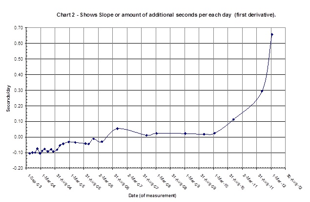
A good stable 10 year battery life digital
watch (Casio Illuminator) was chosen to be compared to
atomic time over a long period of years. The measurements
started in Sep 2003. Six to eight of the best (least
drift between measurements) most stable watches at any one
point in time were averaged to come up with stable “standard
local watch time”. The worst or most unstable readings for
each measurement were not used. Batteries run out on clocks
and change voltage with time. By introducing new
watches and changing batteries when the readings become
unstable one can produce a “stable standard local time” to a
surprising accuracy.
The timekeeper notes that at first the manual watches were
running faster than the atomic clock, but this soon changed. The
Zetas had warned that the Navy would try to get ahead of the
slowing rotation by setting the atomic clock to run faster than
the manual watches. This study documents just such a maneuver by
the Navy at that time, in 2003.
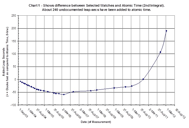
One notes between the Sep 03 and Mar 06
that the drift was negative in that it shows the average of
these clocks ran slower than atomic time. Then as time
went on between Mar 06 and present time more and more
leap-sec’s were added to atomic time to make our standard
watch time appear to run faster and faster, thus overwhelming
the general downward trend before mar 06. Finally near
the end of 2010 the rate began to increase at an ever
increasing rate. If one determines the difference in the
upward trend that started in 2007, continuing for 5 years to
the last reading in 12 Mar 2012, then one gets about 240
leap-second (4 minutes) having been added to atomic
time.
Apparently, noting that slowing had come to a stop, the Navy
relaxed and ignored the issue ever since. But slowing has
returned!
You received this Newsletter because you subscribed to the ZetaTalk
Newsletter service. If undesired, you can quickly Unsubscribe.
|

