| |
ZetaTalk Chat Q&A for August 24, 2013
Can the Zetas comment on this please? Is this a tentative step toward disclosure perhaps? [and from another] CIA acknowledges Area 51
http://www.3news.co.nz/CIA-acknowledges-Area-51/tabid/417/articleID/309396/Default.aspx#ixzz2cBjzfvra It's not the first time the government has acknowledged the existence of the super-secret, 8000-square-mile installation. US Presidents Bill Clinton and George W Bush referred to the "location near Groom Lake" in insisting on continued secrecy, and other government references date to the 1960s. Beginning with the U-2 in the 1950s, the base has been the testing ground for a host of top-secret aircraft, including the SR-71 Blackbird, F-117A stealth fighter and B-2 stealth bomber. Some believe the base's Strangelovian hangars also contain alien vehicles, evidence from the "Roswell incident" - the alleged 1947 crash of a UFO in New Mexico - and extraterrestrial corpses.
As we mentioned years ago in 1995, any alien technology such as space
ships loaned to MJ12 by Service-to-Self aliens, had
been removed from Area 51 as it was too publicly known. This latest
maneuver to allow the admission
that Area 51 existed is thus quite safe. This admission is not disclosure.
It is not admitting the alien presence nor the US government’s past
with aliens such as the Roswell incident. But disclosure is a gradual
process and this is a positive step in the right direction!
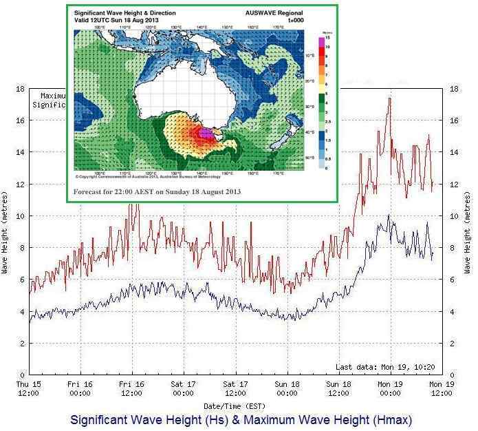
Australia is to experience one of the highest tidal rises in the world on 19th August and following. But nowhere else will along that coast! Perhaps the Zetas would like to comment? [and from another] http://www.theage.com.au/environment/weather/wild-winds-to-batter-victoria-20130818-2s4l8.html Victoria faces more wild weather with rain and high winds forecast for the next few days. [and from another] http://www.abc.net.au/science/articles/2002/05/01/2683462.htm The king of all Australian tides occurs near the town of Derby in King Sound, in north-west Australia, at the end of March and again at the end of April each year. Derby's tides can reach up to 11.8 m, and are the second biggest tides in the world (the largest, clocked at 15 m, occur in the Bay of Fundy, Nova Scotia). [and from another] https://sphotos-a-ams.xx.fbcdn.net/hphotos-prn1/994312_578409588889612_1708258052_n.jpg
This is reported to be a storm surge, but how much of this high tide is
caused by the Earth wobble or plate movements? The graphs show a tidal
surge on August 16, 2013 when there was a rash of earthquakes in New
Zealand, but no such quake swarm occurred on August 19, 2013 when a larger
high tide occurred. We mentioned during the 8 of 10 discussions that there
would be some shifting of plates during the 8
of 10 such that the alignment of continents to each other would change.
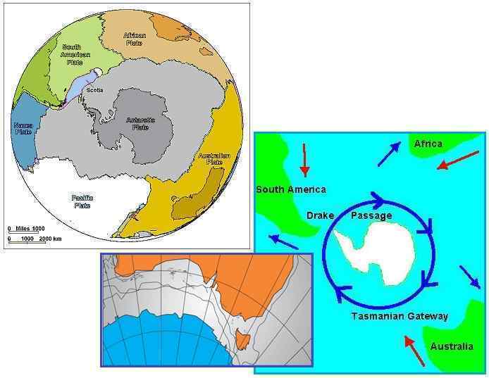
The Antarctic Plate is one that is relatively free to move, not being
locked on any side.
Due to the S American roll, which is caused by the spreading Atlantic,
there is a natural tendency of the Antarctic Plate to roll clockwise,
pushing the tip of S America toward Africa. We have mentioned that the
compression in the Pacific Plates tips the
Antarctic Plate also, which ultimately results in new land emerging
between the tips of S America and Africa. As this roll of the Antarctic
Plate begins, it will also tend to push under
the Indo-Australian Plate, which is in any case lifting on its eastern
edge and thus providing an opening for the Antarctic roll. If such a nudge
up occurs, the water atop the Indo-Australian Plate will slosh, and this
is what occurred on August 19 near Tasmania.
In Russia in late July began flooding in several areas. On august 18 the water level in the Amur River has exceeded the historical maximum. http://poleshift.ning.com/profiles/blogs/unprecedented-flooding-affect-russia-s-far-east It was the second serious warning to the inhabitants of Russia after the floods in Krymsk. And although our friends in detail described the process of Eurasian plate stretching, Amur River is located on the Amur plate. It borders with the Philippines and Okhotsk plates, which are under pressure from the Pacific Ocean. Could our friends to answer - what was the cause of this record flooding in Russia, and how will behave the Amur plate during geological changes? What can wait for the residents of the area in the future, when the tidal waves hit the coast, where the Amur River flows, because on a way of waves located Sakhalin Island? What can happen with the inhabitants of the island, after all the island is very narrow?
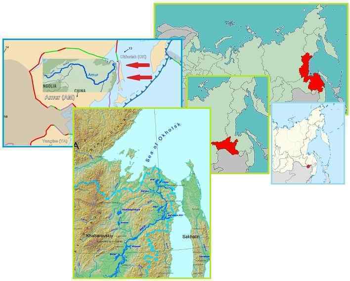
Why is the Amur River basis suddenly flooding? The river winds its way
through the mountains of East Russia, and is a major river, combining the
water flow from several other rivers as tributaries further inland. A
glance at a topo map shows that the Amur winds its way through a
mountainous region before reaching the sea. The Pacific plates are
constantly compressing, subducting or overlapping one another, and pushing
under Japan. What happens inland during this process? The Amur River was
pinched, as it was attempting to dump into the sea, so that the river
emptied more slowly, carried less of a flow, the river bottom rising so
the river depth lessened. Stretch and compression zones both
experience these changes, which cause flooding.
My question is about this article that appeared today on NBC News. It states that the cause of the seiche waves in Norway two years ago was the Japan Earthquake. As the Zetas have said other seiche events were a combination of wobble related and natural wind related, is this the same for this event? http://www.zetatalk.com/index/zeta461.htm If it is just natural, why take two years to announce the findings? Are they preparing for similar type events to become common now that the wobble is getting very strong? Perhaps the timing has something to so with similar articles like the ones in the question above. [and from another] http://www.nbcnews.com/science/norways-weird-waves-traced-japan-quake-6C10946754 [and from another] http://en.wikipedia.org/wiki/Seiche A seiche is a standing wave in an enclosed or partially enclosed body of water. Seiches and seiche-related phenomena have been observed on lakes, reservoirs, swimming pools, bays, harbors and seas. The key requirement for formation of a seiche is that the body of water be at least partially bounded, allowing the formation of the standing wave.
One of the many signs that Planet X is in the vicinity has been the
global shuttering, often happening at regular times of day, and likewise
often following major quakes. The live seismometers worldwide go black.
When Planet X arrived in the inner solar system they showed up twice
a day, when the Atlantic Rift was tugged back by Planet X and when
the rift was in opposition on the dark side of the Earth. The cover-up
over the presence of Planet X, aka Nibiru, quickly reduced the sensitivity
of the seismographs. The establishment was pressed to explain this
pattern, and stonewalled.
Now that the announcement is planned, scientists are anxious to discuss
the Earth changes openly, able at last to put aside the long list of
topics they have not been allowed to discuss except behind closed doors
and in hushed terms. Seiche, where standing waves are formed in an
enclosed body of water outside of any influence by tides, can be a result
of the jiggling that causes the seismometers to go black. The Earth’s
plate touch one another, and transfer jolts, and the Earth’s magma
likewise transfers a type of sloshing motion after large quakes and plate
adjustments. All very logical, and the 2 year delay in reporting this just
another sign that the announcement is close.
This message is circulating Facebook. Is there any validity to it and is announcement-related? https://www.facebook.com/beforeitsnewscom/posts/10151794242039844 [and from another] http://thewatchtowers.com/possible-emergency-alert-for-fema-region-iii/ A few nights ago Donald Trump was with Greta on Fox News. He told her something BIG was going to happen, most likely starting the first week of October. FEMA purchase orders for over $14.2 million for MREs and heater meals to be delivered to Region III by October 1st. FEMA purchase orders for 22 million pouches of emergency water to be delivered to region III by October 1st. FEMA purchase orders for $13.6 million for MREs and heater meals to be delivered to Austin by October 1st. Nine-week training course for UN Peacekeepers in CONUS to learn Urban Warfare, English, and US weapons systems beginning 4th week of July for 386,000 troops to be completed by October 1st. $11 million in antibiotics to be delivered to FEMA region III by October 1st ordered by CDC. No leave will be allowed for US military from September 28th thru November 5th. All DHS agents MUST qualify with sidearm, shotgun and AR 15 by September 28th. POTUS mandates to FEMA and DHS concerning support for metropolitan communities dealing with the extreme climate change MUST be complete by October 1st. These mandates were issued during the last three weeks. Over 300 school systems in the US have determined they need three-day kits for each school AND three-day kits for each student to take with them. All deliveries are scheduled for the month of September. All National Guard units will complete riot control and disaster assistance training during this years annual two week training. All units MUST have their training complete by September 30th. Daily testing of the Emergency Broadcast System to begin on September 25th and run thru October 2nd. [and from another] http://wwwwakeupamericans-spree.blogspot.com/2013/08/fema-preparing-for-worst-in-region-3.html#.UhNEoD_3OFI Region three includes, DC, DE, MD, PA, VA, WV. [and from another] I think it’s extremely interesting that this facebook question coincides with the Prime Minister of Canada seeking a prorogue of government. Is this yet another piece falling into place for the announcement team and those who do not want to deal with the news (Harper and his government)? [and from another] http://www.cbc.ca/news/politics/story/2013/08/19/pol-harper-commons-prorogation.html Stephen Harper to seek prorogation of Parliament. Conservative government plans to kick off fall session with October throne speech. “There will be a new throne speech in the fall, obviously the House will be prorogued in anticipation of that. We will come back — in October is our tentative timing," The Prime Minister's Office later clarified that Harper will ask for Parliament to be prorogued before the scheduled return of the House on Sept. 16, meaning Parliament will not sit again until after the throne speech in October.
Are the clues pointing to October indicative of an October announcement?
They come from varied sources and address varied issues. Donald Trump may
think of himself as on the inside track, but he is not privy to the
announcement date, and his interests are primarily political. For FEMA to
be increasing its inventory in states clustered around Washington DC is
not addressing the entire nation and is likely just the result of an
inventory audit for this cluster of states. And a throne speech in Canada,
which is part of the British Commonwealth, is likely to be addressing the
issue of the aging Queen’s successor.
Recently it has been reported online that there has been an increase in melanism and albinism, among the local wildlife in the Palakkad district of India. ZT has of course spoken of, in fact predicted years ago, the increased incidence of albinism which has been observed among the creatures of Planet Earth, brought about by core emanations symptomatic of the magnetic influence of the incoming PX aka Nibiru. Melanism however, which is the opposite of albinism and results in increased pigmentation, does not appear to have been widely reported in the past. Common sense would indicate that melanism is just another symptom of the radiation confusion being experienced by these affected animals, as with albinism, and especially as it appears to be occurring concurrently with albinism. However, there is nothing like ZT.Would the Z care to throw some more light on this subject? [and from another] http://www.thehindu.com/news/national/kerala/melanism-albino-syndrome-among-palakkad-wildlife/article5035244.ece Albinism is also found among wild animals in these areas. A white sambar was photographed. Melanism and albinism are seen among the wild animals, birds and butterflies in regions close to the equator where evergreen forests are found. melanism is caused by a recessive gene, and the ecosystem of the habitat may not have any influence on the colour change. Melanistic animals can be considered genetic freaks. The presence of melanistic tigers has been reported from the Simlipal National Park of Odisha and the Sunderbans of Bengal. Melanistic animals are found more in dense forests.
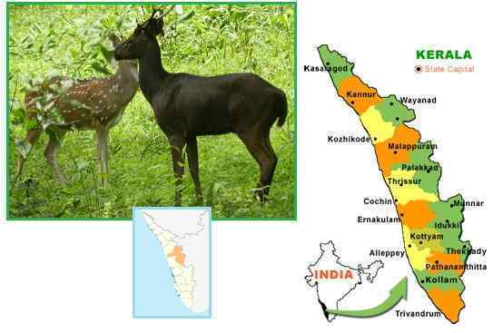
We mentioned at the start of the ZetaTalk saga, when the White
Buffalo calves began to emerge, that genetics for coloration had
two switches – one to increase coloration, and one to decrease it.
Albinism of course is a decrease, triggered by radiation from the core of
the Earth. This particular particle flow is why fish and creatures living
in caves are often colorless, white or opaque in appearance. But given the
extra bright Sun these days, sunlight scattered in the vast dust cloud
standing between Planet X and the Earth, there are additional signals. A
darker color protects creatures from too much radiation, the reason for
the tanning response to bright sunlight. It has been noted for some years
that humans are sunburning more quickly than in the past. More proof
that Planet X stands nearby!
Wondering about the Rio Grande Rift before and after the shift? Is this bow following the rift?
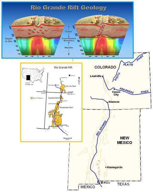
The Rio Grande Rift is a scar on the N American continent that shows the
bowing stress during plate movement has happened before. And why would it
not? The bow stress is caused by the inherent shape of the N American
continent, that being its flat top which prevents a roll. Why has the Rio
Grande Rift not been a focus of ripping during the current bow stress?
Each Pole Shift does not find the continents positioned the same, as the
wandering poles attest. Thus the angle
of tugging changes, from one passage to the next, though the fact that the
Atlantic is pulling apart is a consistent factor.
If the bow stress has recently created a great sinkhole
in Kansas and is rupturing the Salt Dome caverns in Louisiana, then
why not further rupture the Rio Grande Rift which lies between those two
points in the line drawn East from the bow center of San Diego? Doctors
will often state that a fractured bone heals stronger than the original
bone. Thus if the bone were to fracture again, the former fracture is not
likely to be the break point a second time. Hardened lava at the rift is
stronger than the surrounding areas in other states, and thus the stress
of the bow is transferred to the weaker points.
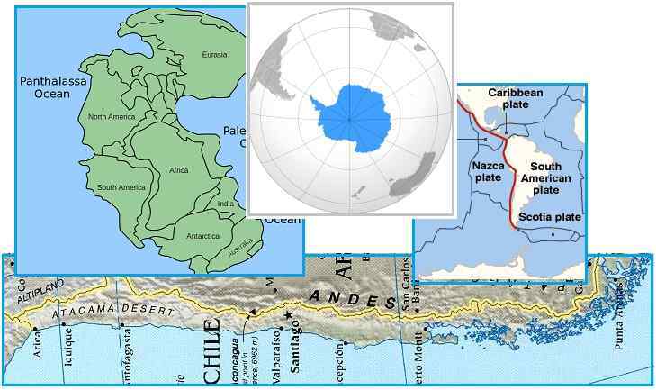
Regarding the South America Roll, for long time I have been trying to figure out how this will affect specifically Chile. You see, Chile is one of the most subject to seismic activity in the world countries, perhaps only equivalent to Japan in that regard. Chile sits right in front of the Ring of Fire as if it were looking to it from the mezzanine. Chile is directly facing the subduction zone by the Nazca Plate going under the South American plate. And South America is under a bowing stress, at the northern border of Chile with Peru, Bolivia and Argentina, product of the displacement of South America at the Equator. Meanwhile, the southern part of Chile is being submitted to a stretching action resulting from the bowing stress up north. Accordingly I´ve been trying to figure out how the combined effect of : 1) The bowing stress tending to create a stretching effect on the Chilean territory at the southern portion of the country, and 2) The subduction stress is pushing under the Chilean territory from the left side. My question is: the combined effects of the subduction stress from the side and the stretching at the southern part will create new fjords upwards to the north, like those already existing down south of Chile? A new channel zone will be created in Chilean territories which at present are just low altitude, but continuous lands?
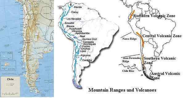
Where S America has retained its essential shape during the drifting
apart of Pangea, there are differences. Most notable is that the tip of
the continent has straightened out! As it was tugged West, away from the
spreading Atlantic, it encountered the rock hard Nazca Plate, and was
pushed to straighten out where this encounter did not block its path. This
bend point can be clearly seen on the coastline of Chile where the
coastline fractures into many island. What will happen to this region when
the Antarctic Plate turns counterclockwise, as it has begun to do,
accentuating the S American roll.
There is a lip on the Antarctic Plate just below the Nazca Plate that will
shove the tip of S America before
it. Where the Atlantic spreads, as it will do to an immense degree during
the Pole Shift, this allows room for the rolling S American Plate to move
its tip into the void in the Atlantic. But until such time, this fractured
tip will cry in pain as the rock is continually under pressure. The
residents of the tip will experience the moaning Earth before others
elsewhere on the globe. Beyond this, Chile finds itself with a direct
confrontation with the hard Nazca Plate, so that subduction
jolts are to be expected.
When land rides above another plate, it can take one of two paths. It can
retain its integrity, taking a smooth ride over the lower plate, or it can
fracture and tumble, creating a rumple. Chile has done both in the past,
and where a thickened edge, composed of rumpled rock and hardened magma,
has developed a smooth slide occurs. This region of Chile is characterized
by a lack of volcanoes along the
coast. But where the subducting Nazca Plate is pushing under a new region
further inland, there volcanic activity can be found, as this hardening
and thickening has not yet progressed sufficiently.